A METAR is a routine observation of weather at a station, normally issued once an hour. A SPECI is a special report when conditions change enough to deserve one. Part 107 cares because §107.49 requires the remote pilot in command to assess local weather before flight, and §107.51 sets a 3-statute-mile visibility minimum and cloud distances the observation helps you judge. Weather is only about 5 percent of the scored UAG test, but the decoding is mechanical. If you can read the groups in order, the questions are short.
Read the groups in order
A training example from the course looks like this:
METAR KXYZ 121853Z 24015G25KT 6SM -RA BKN025 OVC040 18/13 A2992
The station is KXYZ. The date/time 121853Z is the 12th day of the month at 1853 Zulu. Zulu is UTC, not local time. Wind is next: 24015G25KT means from 240 degrees true at 15 knots, gusting to 25 knots. The G marks the gust. VRB means variable direction. 00000KT means calm. Direction is where the wind comes from, not where it is going.
Visibility is in statute miles. 6SM is 6 statute miles. Fractions are written out, as in 1 1/2SM or 1/2SM. Weather phenomena follow. RA is rain, a minus sign is light, BR is mist, FG is fog. Sky cover comes after that. Heights are hundreds of feet above the ground. BKN025 is broken at 2,500 feet AGL. OVC040 is overcast at 4,000 feet AGL. FEW (1/8–2/8) and SCT (3/8–4/8) do not form a ceiling. SKC or CLR means clear. The ceiling is the lowest broken or overcast layer. In the example, the ceiling is 2,500 feet AGL, not 4,000, because BKN is the first of those two.
Temperature and dew point are degrees Celsius, written temperature/dew point. 18/13 is 18 °C and a dew point of 13 °C. An M means minus, so M04/M09 is negative temperatures. A close temperature and dew point means moisture is high and visibility can fall. The altimeter is the A group in inches of mercury. A2992 is 29.92. A3000 is 30.00. It is not a flight level and it is not the temperature.
Figure 12, the supplement page
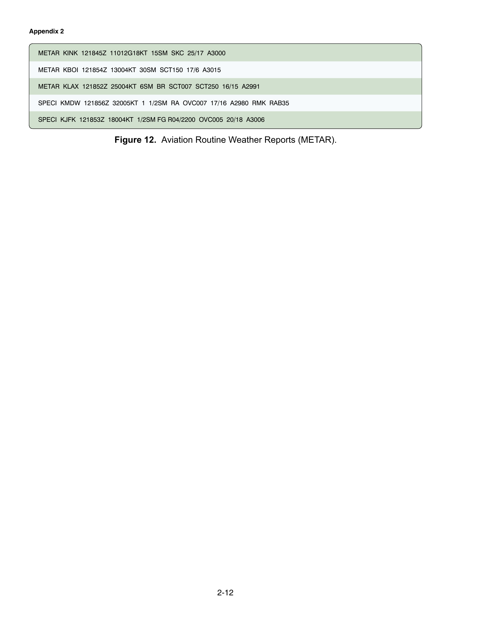
FAA-CT-8080-2H Figure 12 is a sheet of routine and special reports. The course questions use the printed lines, not a rewritten story.
The KINK report includes 11012G18KT. That is wind from 110 degrees true at 12 knots, gusting to 18. It also includes 25/17 and A3000: temperature 25 °C, dew point 17 °C, altimeter 30.00 inches of mercury.
The KMDW special includes 1 1/2SM RA OVC007. Visibility is one and one-half statute miles in rain, with an overcast ceiling at 700 feet AGL. That visibility is already below the Part 107 minimum of 3 statute miles in §107.51(c), measured from the control station.
The KLAX line in the same figure includes 6SM BR SCT007. Six statute miles meets the visibility number. SCT007 is scattered clouds at 700 feet AGL. Scattered is not a ceiling. Mist is still a reason to look outside and confirm what you can actually see from the control station. A METAR at the airport is a source. It is not a substitute for the visibility you observe at the launch point if they differ.
Where this meets the go or no-go
Section 107.51(c) requires at least 3 statute miles of flight visibility, observed from the control station. Section 107.51(d) requires the aircraft to stay at least 500 feet below the cloud and 2,000 feet horizontally from it. A METAR that says 2SM, or a ceiling that leaves you without 500 feet under the cloud inside your 400-foot altitude cap, is a no-go for a standard operation even when the wind looks flyable.
A METAR is not a forecast. If the question gives you a valid period such as 1218/1318, or the word TEMPO, you are looking at a TAF. Same weather codes, different product. The header is how you tell them apart. Forecasts are the next page, how to read a TAF.
Temperature in the METAR also feeds performance. A hot temperature at a high-elevation site is the setup for high density altitude, covered under density altitude. Decode the observation first. Then decide whether the number is legal and whether the aircraft can still perform.