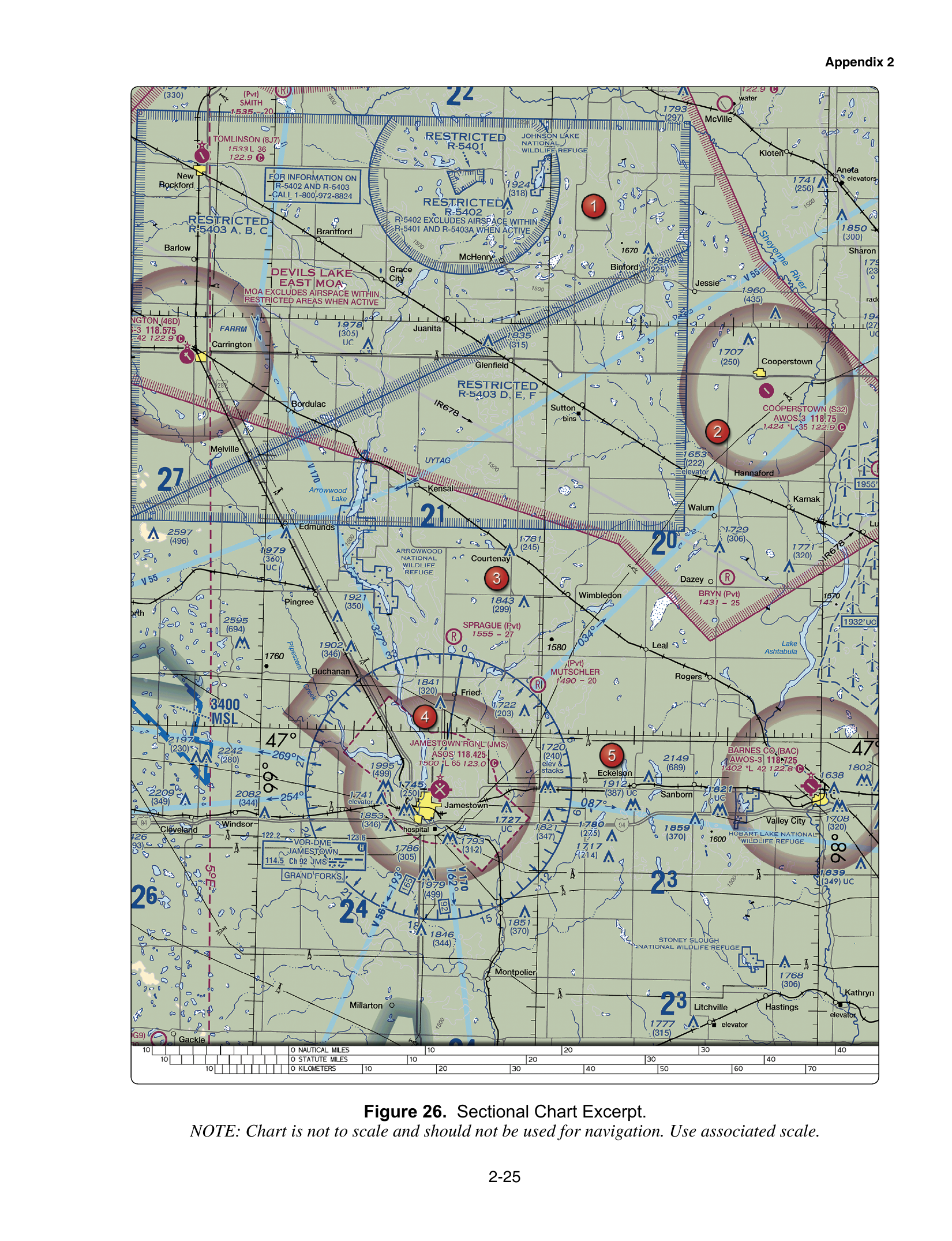
A dashed magenta line around an airport means Class E airspace begins at the surface. Inside the lateral boundaries of that surface area, §107.41 requires prior ATC authorization before a Part 107 flight. The airport is often non-towered. The missing tower does not remove the authorization. A faded magenta vignette and a faded blue vignette are different floors, 700 and 1,200 feet AGL, and they are not this surface area.
Dashed magenta is the surface
The Chart Users' Guide symbolizes Class E surface airspace with a magenta dashed line. The terminology item keys that depiction: Class E beginning at the surface. Class B is a solid blue line. A prohibited area is a special-use depiction, not a dashed magenta airport boundary.
The follow-up item asks which depiction is the surface and then names the lookalikes. A dashed magenta boundary is Class E at the surface. A faded magenta vignette generally indicates a 700-foot AGL floor. A faded blue vignette indicates a 1,200-foot AGL floor. Fade means the Class E starts above you. Dash means it starts on the ground. The above-the-surface floors, and the Class G that often sits under them, are on the Class E airspace page. Class D uses a dashed blue line, so the color of the dash is the whole distinction between Class D and surface Class E. That blue dash is on the Class D page.
Section 107.41 states the operating rule in one sentence: no person may operate a small unmanned aircraft in Class B, Class C, or Class D airspace or within the lateral boundaries of the surface area of Class E airspace designated for an airport unless that person has prior authorization from ATC. "Within the lateral boundaries" means the authorization applies to the footprint of that dashed magenta area, from the surface up through the altitudes where the surface area is designated. A flight at 100 feet AGL inside the dashes is inside the rule. The pilot who thinks "there is no tower, so this is just a Class G county field" has missed the symbol.
LAANC or DroneZone is how the prior authorization is obtained. Listening to the ASOS, calling UNICOM, or self-announcing on the CTAF supports the §107.49 weather assessment and the §107.43 duty not to interfere with the traffic pattern. None of those radio acts is the ATC authorization.
The Jamestown block is a non-towered airport's data, not a clearance
FAA-CT-8080-2H Figure 26 prints Jamestown Regional's data block in magenta. The block shows ASOS 118.425 above the line 1500 *L 65, and 123.0 with a circled C. The keyed reading is: elevation 1,500 feet MSL, lighting limitations exist, the longest runway is 6,500 feet, and 123.0 is the CTAF.
Magenta on an airport symbol means the airport has no control tower. The bottom line of the data block is field elevation in feet MSL, then lighting, then the longest runway in hundreds of feet. 1500 is 1,500 feet MSL. *L means lighting limitations exist, so you check the Chart Supplement. It does not mean the tower operates part time. 65 is 6,500 feet of runway, not a runway 65 feet wide and not a width at all. The circled C marks the CTAF, here 123.0. ASOS 118.425 is the automated weather broadcast. It is not the CTAF.
The wrong readings collapse those fields. One of them invents a part-time control tower on 123.0, a runway 65 feet wide, and an elevation of 150 feet AGL. Another treats *L as a part-time tower and treats 118.425 as the CTAF. The print supports none of that. No tower, elevation 1,500 feet MSL, lighting limitations, runway length 6,500 feet, CTAF 123.0, weather on 118.425.
The data block tells you the airport has no tower and tells you how to listen. If the sectional also draws dashed magenta around that kind of airport, the airspace rule is still §107.41. Read the boundary and the data block as two different sentences. The boundary is the authorization question. The block is elevation, lighting, runway length, weather, and CTAF.
Inside the dashes at a field with no tower
You open the sectional on a mapping job and find a dashed magenta ring around a non-towered airport. The airport symbol is magenta. You plan to work inside the ring at 200 feet AGL. The dashed magenta line is Class E to the surface, so the lateral boundaries are the §107.41 boundary. You obtain prior ATC authorization before launch. You do not skip it because nobody is in a tower cab. If LAANC shows a grid ceiling of 100 feet, 200 feet is above the authorization even though it is under the Part 107 400-foot rule.
You still read the data block the way Figure 26 trains you to read Jamestown. Elevation is feet MSL, so you know how high the ground is when you convert a chart altitude. *L sends you to the Chart Supplement for the lighting note. The circled C is the frequency you monitor for traffic. The ASOS frequency is where you listen to the weather. Monitoring 118.425 does not put you on CTAF, and announcing on CTAF does not create the airspace authorization.
Outside the dashes, if the only Class E mark is a faded magenta vignette, you are back to a 700-foot floor and, below it, often Class G. That is a different symbol and a different authorization answer. Do not promote a vignette into a surface area because an airport is nearby.
The trap
The symbol trap calls dashed magenta Class B or a prohibited area, or swaps it for a faded vignette. Dashed magenta is Class E at the surface. Faded magenta is generally 700 feet AGL. Faded blue is 1,200 feet AGL.
The authorization trap is the non-towered airport. No tower cab does not mean no §107.41. Prior ATC authorization is required inside the lateral boundaries.
The data-block trap on Figure 26 misreads 1500, *L, 65, and the frequencies. Elevation 1,500 feet MSL, lighting limitations, longest runway 6,500 feet, CTAF on the circled C at 123.0, ASOS on 118.425. *L is not a part-time tower, and the weather frequency is not the CTAF.
Practice the dashed magenta items on the free practice test. The chart lessons in the course put Figure 26's data block next to the surface-area rule so a magenta airport is not mistaken for uncontrolled airspace.