Astra Pilot AcademyAstra Pilot Academy
How it worksPlatformCurriculumStudyPractice testReviewsGuaranteeFAQFor teamsPricing
Log inOrganization login
Enroll now
Astra Pilot AcademyAstra Pilot Academy

Part 107 exam prep for the FAA knowledge test: study guides, a free practice test, and a course built on real FAA charts.

Product
  • Curriculum
  • Study guides
  • Free practice test
  • 12-question diagnostic
  • Pricing
  • Astra Pro
  • Guarantee
  • For Teams
Support
  • FAQ
  • Log in
  • Renew / recurrent
Legal
  • Terms of Service
  • Privacy Policy

© 2026 Astra Pilot Academy. All rights reserved.

Astra Pilot Academy is not affiliated with, endorsed by, or sponsored by the Federal Aviation Administration (FAA). Course-completion credential, not an FAA remote pilot certificate. FAA fees and passing score — confirm current details at faa.gov. FAA charts are public-domain U.S. Government works.

Home/Part 107 study guides/Sectional chart symbols for Part 107

Airspace and charts

Sectional chart symbols for Part 107

How to read sectional airport symbols, the circled C, obstruction heights, and the legend on FAA-CT-8080-2H figures.

Practice, then train

Practice Sectional chart symbols for Part 107 on the free Part 107 test

The free 20-question practice test follows the PSI topic weights, including chart figures, and scores you against the FAA's 70% mark. The individual course is $50 for the first 10 founding seats, then $149. If you meet the published conditions and fail your first FAA attempt, the pass guarantee is a course-price refund of what you paid us. It does not include PSI or FAA testing fees.

Take the free practice testSee pricing

Sectional-chart questions do not reward memorizing every airport in the supplement. They reward reading one symbol, one data block, and one altitude the way the legend defines them. The FAA Chart Users' Guide and FAA-CT-8080-2H Legend 1 are the keys. Starting October 26, 2026, the UAG test also uses current chart images that are not in the printed supplement, so the skill is the legend, not a memorized figure number.

Airport symbols: color, then the star

On a VFR sectional, a blue airport symbol means the airport has a control tower. A magenta airport symbol means it does not. That is the color rule in Legend 1 and in the Chart Users' Guide airport key. A star beside the tower information means the tower operates part time. The hours live in the Chart Supplement, not in the color of the ink.

Two traps show up constantly. First, magenta does not mean "tower closed right now," and blue does not mean "tower open right now." The symbol describes whether a tower exists. Part-time status is the star plus the directory. Second, color is not a runway-length code. Runway length is a number in the data block, printed in hundreds of feet.

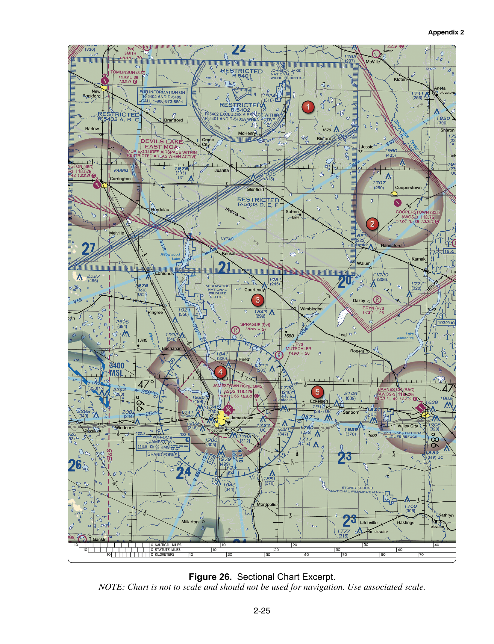
FAA-CT-8080-2H Figure 26 is a clean practice picture. Jamestown Regional's data block is magenta, so there is no tower. The block shows ASOS 118.425, then 1500 *L 65, then 123.0 with a circled C. Read that bottom line as field elevation 1,500 feet MSL, lighting limitations (*L, so check the Chart Supplement), longest runway 6,500 feet, and CTAF 123.0. The ASOS frequency is weather, not the CTAF.

The data block, left to right

Airport data blocks are small, and the test asks you to pick one fact out of them. The usual bottom line is elevation in feet MSL, then lighting, then the longest runway in hundreds of feet. A star or *L on the lighting means the lighting has limitations. The Chart Supplement has the detail. Do not turn 65 into 65 feet. Multiply by 100.

Frequencies sit above or beside that line, and the label matters more than the digits. ATIS, ASOS, and AWOS are weather broadcasts. CT is a control tower. A C inside a circle is the CTAF, the frequency pilots use to announce themselves at a non-towered airport or when the tower is closed. Field elevation is a number of feet, not a frequency. If a choice calls the circled C an ATIS, it is swapping two different services that often sit in the same block.

A boxed navaid near the airport is a third thing. A VORTAC or VOR/DME frequency is not the tower and not the CTAF. On Figure 20 the Norfolk VORTAC is 116.9, while the airport block separately prints CT 120.8 and ATIS 127.15. Read the box you were asked about.

Obstructions

Obstruction symbols print two heights. The bold top number is the top of the obstruction in feet above mean sea level. The number in parentheses is the height above ground. A symbol that reads 2,049 over (1,149) is 2,049 feet MSL and 1,149 feet AGL. Adding the two numbers, or treating the parenthetical as MSL, is the usual miss. The Chart Users' Guide also notes that UC means under construction or unverified, and that the symbol shape distinguishes shorter towers from towers 1,000 feet AGL and higher.

Those heights matter twice. They tell you the obstacle. They also feed the structure exception in §107.51(b): within 400 feet horizontally of a structure, you may fly up to 400 feet above the structure's immediate uppermost limit. The AGL figure in parentheses is the one you add to, not the MSL figure.

Maximum Elevation Figure, briefly

Each quadrant of latitude and longitude carries a Maximum Elevation Figure. It is the highest terrain or obstruction in that quadrant, rounded up as the charting rules specify, plus a buffer. It is not a regulatory altitude and it is not permission to fly there. For Part 107 it is a planning clue: if the MEF is high, obstacles in that box are high, and your 400-foot AGL cap still applies unless the structure exception applies to one specific structure.

How to practice a figure question

When a stem says "refer to Figure 26" or "Legend 1," open that page and read the printed label before you look at the choices. The FAA's September 2026 testing advisory says that from October 26, 2026, some UAG chart questions use current sectional images that are not in the supplement, and that active test images are not released for preview. The legend skills above still transfer: tower color, circled C, elevation, runway in hundreds of feet, and MSL versus AGL.

Pair this page with airspace classes and with latitude and longitude, which is how you state where on the chart the symbol sits.
Sources

  • FAA Aeronautical Chart Users' Guide, edition effective 22 Jan 2026
  • FAA-CT-8080-2H, the airman knowledge testing supplement used with these figures
  • Remote Pilot ACS (FAA-S-ACS-10B)
  • Remote Pilot study guide (FAA-G-8082-22)

Astra Pilot Academy is not affiliated with the FAA. Rules and fees change. Confirm the current text before you fly or schedule a test.

Chart figures

These are public-domain FAA test-supplement figures already used in the course. Read the printed labels. The sample questions below use the same figures when they say to refer to one.

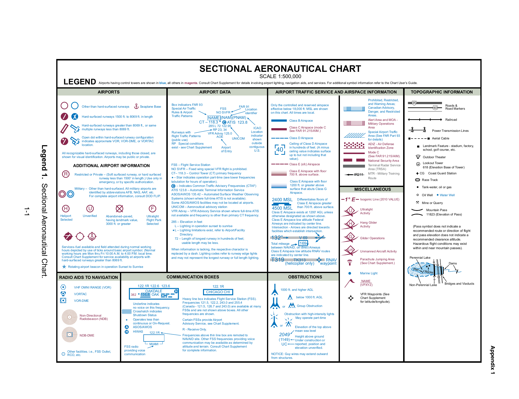
Sectional chart legend (symbol key). FAA-CT-8080-2H Legend 1.
Sectional chart legend (symbol key) · FAA-CT-8080-2H Legend 1. FAA-CT-8080-2H Legend 1 (Sectional Aeronautical Chart), supplement page 1-1, rotated to landscape. U.S. Government work — public domain.
Restricted areas & non-towered airport. FAA-CT-8080-2H Figure 26.
Restricted areas & non-towered airport · FAA-CT-8080-2H Figure 26. FAA-CT-8080-2H Figure 26 (Jamestown, North Dakota), supplement page 2-25. U.S. Government work — public domain.

Sample questions

Three items from the course question bank. Each has the same three choices the bank uses. Open the explanation to see the keyed answer. These are not new questions.

  1. Question 1

    (Refer to FAA-CT-8080-2H Legend 1.) In the airport data key, a C drawn inside a circle next to a frequency identifies which service?

    • AATIS, the recorded airport weather broadcast
    • BThe Common Traffic Advisory Frequency (CTAF)
    • CField elevation, in feet above mean sea level
    Show explanation

    Answer B. The Common Traffic Advisory Frequency (CTAF)

    Legend 1's airport data key marks the CTAF with a C inside a circle. ATIS and ASOS are labeled as separate broadcasts, and field elevation is the first number on the bottom line of the data block, not a circled letter.

  2. Question 2

    (Refer to FAA-CT-8080-2H Legend 1.) What do the blue and magenta airport symbols mean, and what does a star beside the control-tower information mean?

    • ABlue means the airport has a control tower, and magenta means it does not. A star means the tower is part-time, so check the hours.
    • BBlue means the runway is longer than 5,000 feet. A star means pilot-controlled lighting.
    • CMagenta means a control tower is operating now. A star means the airport is closed.
    Show explanation

    Answer A. Blue means the airport has a control tower, and magenta means it does not. A star means the tower is part-time, so check the hours.

    Legend 1 prints airports with control towers in blue and airports without them in magenta. A star by the tower data means the tower operates part time; the Chart Supplement has the hours. The symbol color does not say the tower is open at the moment you fly.

  3. Question 3

    An obstruction labeled 2,049 in bold with (1,149) below indicates the obstruction top is:

    • A1,149 feet MSL
    • B2,049 feet MSL and 1,149 feet AGL
    • C3,198 feet MSL
    Show explanation

    Answer B. 2,049 feet MSL and 1,149 feet AGL

    Bold MSL / parentheses AGL.

FAQ

What does a blue airport symbol mean on a sectional?

A blue airport symbol means the airport has a control tower. A magenta airport symbol means it does not. A star means the tower is part time, so you check the Chart Supplement for the hours. The color does not tell you the tower is open at the moment you fly.

What is the circled C in an airport data block?

Legend 1 marks the Common Traffic Advisory Frequency with a C inside a circle. It is not the ATIS, the ASOS, or the field elevation.

Which obstruction number is MSL?

On an obstruction symbol the bold top number is height in feet MSL. The number in parentheses is height in feet AGL. An obstruction labeled 2,049 over (1,149) tops out at 2,049 feet MSL and 1,149 feet AGL.

Related study guides

  • Part 107 airspace classes
  • Chart latitude and longitude
  • Magenta and blue airspace lines
  • MOAs and restricted areas
  • NOTAMs for Part 107

Practice, then train

Practice Sectional chart symbols for Part 107 on the free Part 107 test

The free 20-question practice test follows the PSI topic weights, including chart figures, and scores you against the FAA's 70% mark. The individual course is $50 for the first 10 founding seats, then $149. If you meet the published conditions and fail your first FAA attempt, the pass guarantee is a course-price refund of what you paid us. It does not include PSI or FAA testing fees.

Take the free practice testSee pricing