Astra Pilot AcademyAstra Pilot Academy
How it worksPlatformCurriculumStudyPractice testReviewsGuaranteeFAQFor teamsPricing
Log inOrganization login
Enroll now
Astra Pilot AcademyAstra Pilot Academy

Part 107 exam prep for the FAA knowledge test: study guides, a free practice test, and a course built on real FAA charts.

Product
  • Curriculum
  • Study guides
  • Free practice test
  • 12-question diagnostic
  • Pricing
  • Astra Pro
  • Guarantee
  • For Teams
Support
  • FAQ
  • Log in
  • Renew / recurrent
Legal
  • Terms of Service
  • Privacy Policy

© 2026 Astra Pilot Academy. All rights reserved.

Astra Pilot Academy is not affiliated with, endorsed by, or sponsored by the Federal Aviation Administration (FAA). Course-completion credential, not an FAA remote pilot certificate. FAA fees and passing score — confirm current details at faa.gov. FAA charts are public-domain U.S. Government works.

Home/Part 107 study guides/Chart latitude and longitude

Airspace and charts

Chart latitude and longitude

How latitude and longitude work on a sectional: equator, Greenwich, minutes, and why runway numbers are magnetic.

Practice, then train

Practice Chart latitude and longitude on the free Part 107 test

The free 20-question practice test follows the PSI topic weights, including chart figures, and scores you against the FAA's 70% mark. The individual course is $50 for the first 10 founding seats, then $149. If you meet the published conditions and fail your first FAA attempt, the pass guarantee is a course-price refund of what you paid us. It does not include PSI or FAA testing fees.

Take the free practice testSee pricing

Latitude and longitude are how a sectional names a point when "near the airport" is not precise enough. The Part 107 test asks two versions. One is the definition. The other is a unit conversion from decimal degrees into degrees and minutes. A third, closely related item asks which printed numbers are magnetic instead of true. The three are easy to mix because they all live on the same chart.

The two directions

Latitude is angular distance north or south of the equator. Lines of latitude run east-west across the chart. Longitude is angular distance east or west of the Prime Meridian, the line through Greenwich. Lines of longitude, the meridians, run north-south and meet at the poles. The trap answer swaps them: it says latitude is measured east and west from Greenwich, or it says both are measured from the equator. Only latitude is measured from the equator. Only longitude is measured from Greenwich.

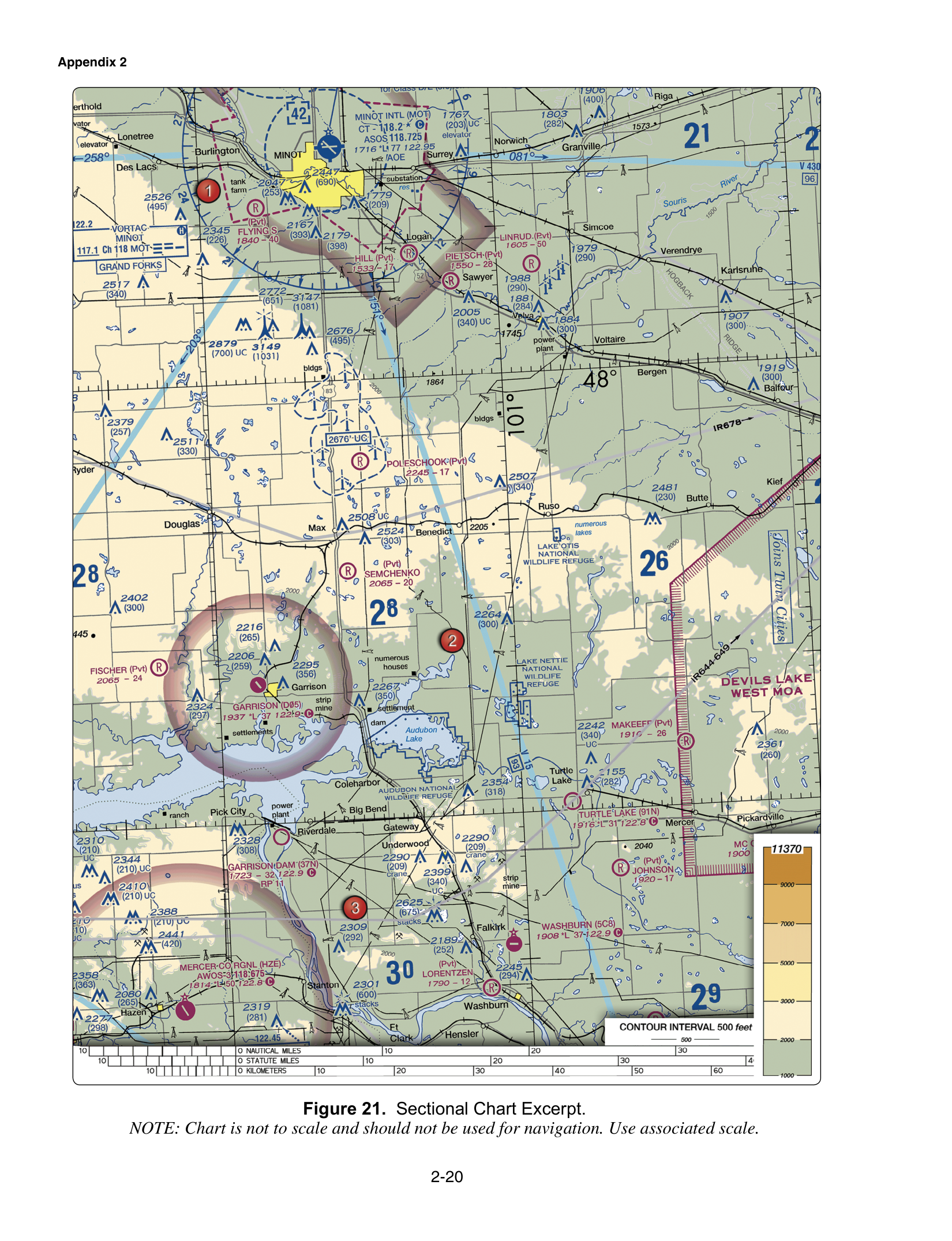
On a sectional the ticks along the edge mark degrees and minutes. The Chart Users' Guide describes the Maximum Elevation Figure quadrants as the areas bounded by ticked lines dividing each 30 minutes of latitude and each 30 minutes of longitude. You do not need the MEF to answer a pure lat/long item, but the ticks you use to locate a point are the same ticks that box the MEF. Figure 21, the Minot–Garrison excerpt, is the course figure that shows those ticks in the same view as MOA airspace. Locate the point first. Then decide what airspace the point sits in. The skills are separate.

Decimal degrees to minutes

A degree contains 60 minutes. To convert a decimal latitude, multiply the fraction by 60. A position given as 41.25°N, with no chart in front of you, is 41 degrees plus 0.25 times 60 minutes. That product is 15, so the latitude is 41°15'N. It is not 41°25'N. The digits after the decimal are not the minute count. It is also not 41°2.5'N from sliding the decimal point. The same arithmetic works for longitude.

If a question gives you the minutes already, do not convert them again. 41°15'N is already in degrees and minutes. 41.25°N is the decimal form of that same latitude. The same step on a different number: 32.50°N is 32°30'N, and 32.75°N is 32°45'N. Half a degree is 30 minutes. Three quarters of a degree is 45 minutes. The digits after the decimal are a fraction of a degree, not a minute count you can copy.

If a question asks for a distance in nautical miles, it is asking a different skill than this conversion. The lat/long items tied to this page ask which direction each coordinate measures, and how to turn a decimal degree into degrees and minutes.

True meridians, magnetic runways

Chart meridians point to true north. The numbers around a VOR compass rose are oriented to magnetic north. Runway numbers are the magnetic heading, rounded to the nearest 10 degrees. Runway 15 is about 150 degrees magnetic, not a latitude. Isogonic lines, where the chart prints them, show the variation between magnetic north and true north. The test item is the category, not a conversion: if the question asks what the compass rose and the runway numbers are referenced to, the answer is magnetic north, not true north and not grid north.

METAR wind is a different true-north product. Wind in a METAR is degrees true. Do not "correct" it to the runway number without being asked. That decoding lives on the METAR page.

Using the grid on a real question

When a figure question says "area 2" or describes a point, the ticks tell you which box. Read the latitude ticks on the side and the longitude ticks on the top or bottom. Then read the airspace symbol inside the box, using the symbol and airspace class pages. A correct lat/long conversion does not answer an airspace question, and a correct airspace read does not fix a swapped equator and Greenwich.
Sources

  • FAA Aeronautical Chart Users' Guide, edition effective 22 Jan 2026
  • Remote Pilot study guide (FAA-G-8082-22)
  • Remote Pilot ACS (FAA-S-ACS-10B)

Astra Pilot Academy is not affiliated with the FAA. Rules and fees change. Confirm the current text before you fly or schedule a test.

Chart figures

These are public-domain FAA test-supplement figures already used in the course. Read the printed labels. The sample questions below use the same figures when they say to refer to one.

MOAs & lat/long (Minot–Garrison, ND). FAA-CT-8080-2H Figure 21.
MOAs & lat/long (Minot–Garrison, ND) · FAA-CT-8080-2H Figure 21. FAA-CT-8080-2H Figure 21 (Minot–Garrison, North Dakota), supplement page 2-20. U.S. Government work — public domain.

Sample questions

Three items from the course question bank. Each has the same three choices the bank uses. Open the explanation to see the keyed answer. These are not new questions.

  1. Question 1

    On a sectional chart, lines of latitude and longitude measure which directions?

    • ALatitude east/west from Greenwich; longitude north/south from the equator
    • BBoth latitude and longitude north/south from the equator
    • CLatitude north/south from the equator; longitude east/west from Greenwich
    Show explanation

    Answer C. Latitude north/south from the equator; longitude east/west from Greenwich

    Latitude measures angular distance north or south of the equator. Longitude measures angular distance east or west of the Prime Meridian through Greenwich.

  2. Question 2

    A position is given as 41.25°N. There is no chart figure. What is that latitude in degrees and minutes?

    • A41°15'N, because 0.25 degree times 60 minutes per degree is 15 minutes
    • B41°25'N, because the digits after the decimal are already the minutes
    • C41°2.5'N, because the decimal is moved one place
    Show explanation

    Answer A. 41°15'N, because 0.25 degree times 60 minutes per degree is 15 minutes

    A minute of latitude is 1/60 of a degree. Multiplying the fractional degree 0.25 by 60 gives 15 minutes, so 41.25°N is 41°15'N. The digits after the decimal are not themselves the minute count.

  3. Question 3

    On a VFR sectional chart, the numbers around a VOR compass rose and the runway numbers printed at an airport are referenced to:

    • AMagnetic north
    • BTrue north
    • CGrid north
    Show explanation

    Answer A. Magnetic north

    The FAA Aeronautical Chart Users' Guide orients VOR compass roses to magnetic north, and runway numbers are the magnetic heading rounded to the nearest 10 degrees. Chart meridians point to true north, and isogonic lines show magnetic variation. Do not treat every printed course or bearing on a sectional as true.

FAQ

Which direction is latitude?

Latitude measures angular distance north or south of the equator. Longitude measures angular distance east or west of the Prime Meridian through Greenwich. Swapping those directions is the usual wrong answer.

How do you convert 41.25 degrees north to degrees and minutes?

A minute is 1/60 of a degree. Multiply the fractional part, 0.25, by 60. That is 15 minutes, so 41.25°N is 41°15'N. The digits after the decimal are not already the minutes.

Are the lines on the chart magnetic?

Meridians point to true north. Runway numbers and the numbers around a VOR compass rose are referenced to magnetic north. Isogonic lines show magnetic variation. Do not treat every course printed on the sectional as true.

Related study guides

  • Sectional chart symbols for Part 107
  • MOAs and restricted areas
  • Part 107 airspace classes
  • Magenta and blue airspace lines
  • NOTAMs for Part 107

Practice, then train

Practice Chart latitude and longitude on the free Part 107 test

The free 20-question practice test follows the PSI topic weights, including chart figures, and scores you against the FAA's 70% mark. The individual course is $50 for the first 10 founding seats, then $149. If you meet the published conditions and fail your first FAA attempt, the pass guarantee is a course-price refund of what you paid us. It does not include PSI or FAA testing fees.

Take the free practice testSee pricing