Airspace class is one of the highest-yield chart topics on the Unmanned Aircraft General (UAG) knowledge test. The current PSI bulletin weights airspace at 20 percent of the scored questions. The ACS lists airspace classification, operating requirements, and flight restrictions as a knowledge area. You are not asked to recite every shelf in the country. You are asked which class you are in, what the chart symbol means, and whether you need authorization before launch.
The six classes, in the order the test uses
Controlled airspace is airspace where some or all aircraft may be subject to air traffic control. The FAA Chart Users' Guide lists Class A, Class B, Class C, Class D, Class E at the surface, and other Class E. Class G is the remaining airspace: it has not been designated as A, B, C, D, or E.
Class A in the United States runs from 18,000 feet MSL up to FL600. Sectional charts do not draw it. It matters on the test mostly as a distractor. A small unmanned aircraft under Part 107 is capped at 400 feet above the ground unless it is within 400 feet of a structure and stays within 400 feet above that structure's top. You will not plan a normal Part 107 job in Class A.
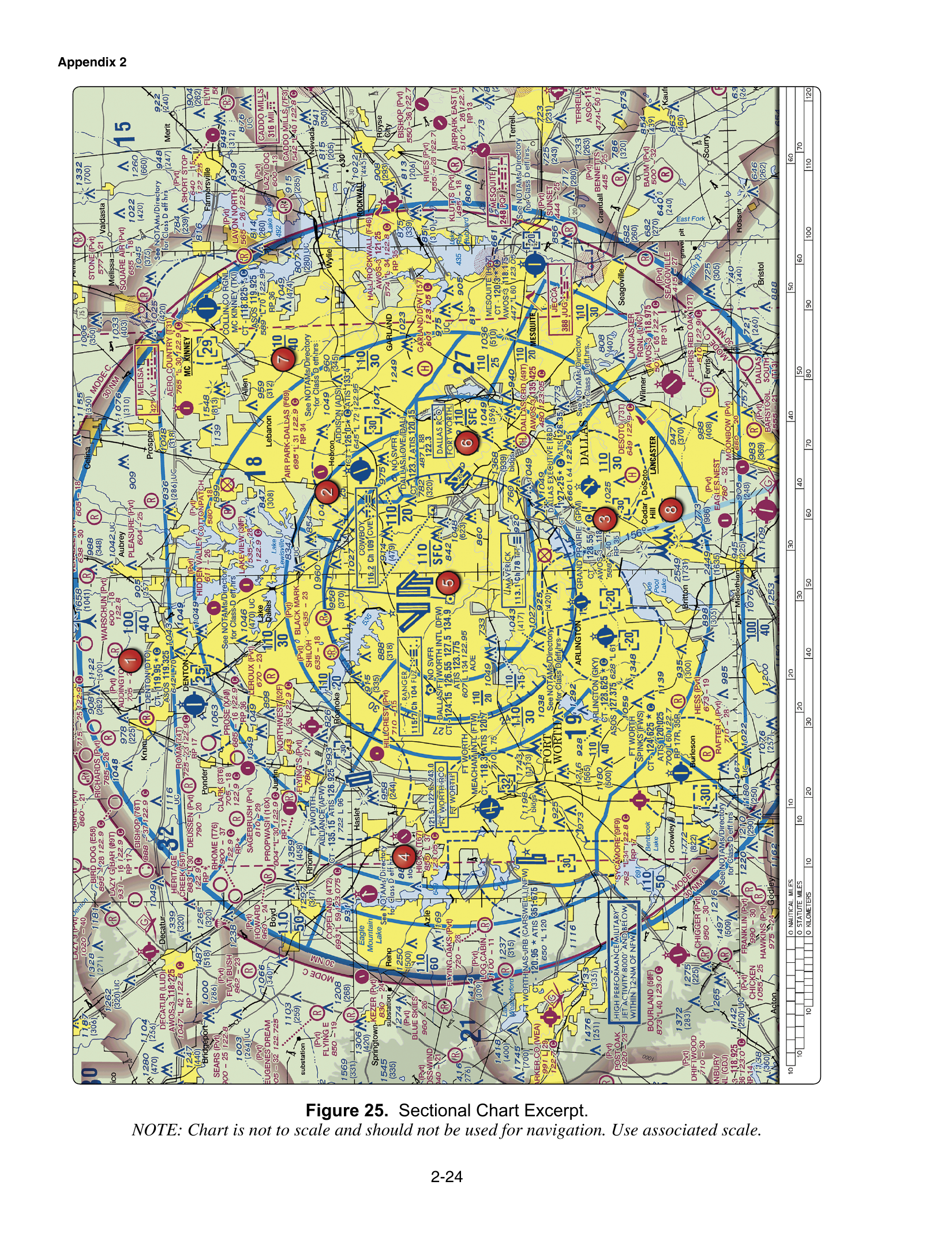
Class B surrounds the busiest airports. On a sectional it is a solid blue line. Ceiling and floor altitudes are printed in solid blue figures, in feet MSL, with the last two zeros omitted. A label of 110 over SFC means the surface to 11,000 feet MSL. A plus sign before a floor means the floor is "upward from above" that altitude, so you are outside Class B at and below the printed floor. On FAA-CT-8080-2H Figure 25, the Dallas–Fort Worth Class B core is the picture the course uses for this label.
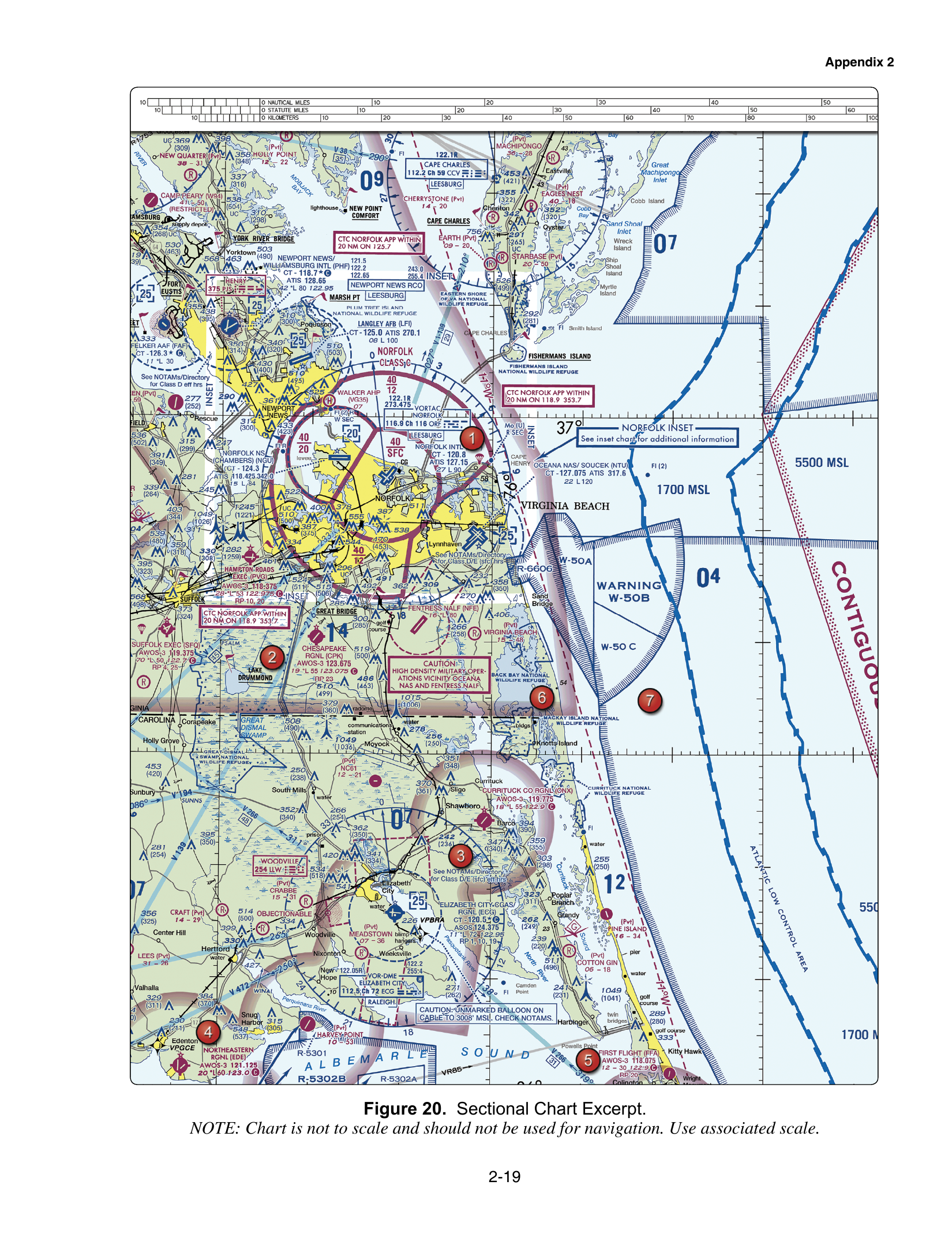
Class C surrounds many medium airports. It is a solid magenta line. Altitudes are solid magenta figures, again MSL with two zeros removed. FAA-CT-8080-2H Figure 20 prints Norfolk's surface sector as 40 over SFC, which is the surface to 4,000 feet MSL. A ceiling printed as T means up to, but not including, the floor of the Class B above it. Class C is often a surface core plus a shelf.
Class D is the airspace around many towered airports that are not busy enough for Class C. It is a dashed blue line, usually a cylinder from the surface to a charted MSL ceiling. A minus sign in front of the ceiling means "from the surface up to but not including" that altitude. Figure 25 prints Addison as [-30], which is up to but not including 3,000 feet MSL. Part-time Class D is noted on the chart. When the tower is closed, the airspace may change. Read the Chart Supplement and NOTAMs for the hours. Do not assume the dashed blue ring is Class D all night.
Class E is controlled airspace that is not A, B, C, or D. It fills a lot of the country. The Chart Users' Guide says Class E exists at 1,200 feet AGL unless designated otherwise. A magenta vignette (a faded magenta band) marks a floor of 700 feet AGL. A blue vignette marks a floor other than 700 feet that abuts Class G, commonly 1,200 feet AGL. Dashed magenta around an airport means Class E starts at the surface. That surface area is the one that triggers §107.41.
Class G is uncontrolled airspace. AIM 3-3-1 describes it as airspace that has not been designated Class A, B, C, D, or E. It often runs from the surface up to the overlying Class E floor, commonly 700 or 1,200 feet AGL, but that is not a fixed ceiling. Where no other class is designated, the Chart Users' Guide says Class G extends up to 14,500 feet MSL, and Class E begins at and above that altitude, with the guide's stated exceptions. Class G can sit under a Class B or Class C shelf. It does not exist inside the lateral and vertical limits of Class B, C, D, or surface Class E.
What Part 107 adds on top of the class
Knowing the class is not the whole question. Section 107.41 says no person may operate a small unmanned aircraft in Class B, Class C, or Class D, or within the lateral boundaries of the surface area of Class E designated for an airport, unless that person has prior authorization from air traffic control. Class G does not, by itself, require that authorization. "No authorization" does not mean "no rules." Visibility, cloud clearance, the 400-foot limit, visual line of sight, and the right-of-way rule still apply in Class G.
Authorization is not a phone call to the tower as you walk onto the site, and it is not a waiver. The usual paths are LAANC, checked against the UAS Facility Map grid, or the FAADroneZone manual process where LAANC is not available. A LAANC approval is capped at the grid ceiling. If the grid says 200 feet, 400 feet is not authorized just because §107.51 would otherwise allow 400.
A worked example
You are hired to photograph a roof in three places on the same sectional.
Site 1 sits inside a solid blue line labeled 110 over SFC. That is Class B from the surface. You need prior ATC authorization, and you may not assume the 400-foot Part 107 cap is already approved.
Site 2 sits inside a dashed blue ring with a boxed ceiling. That is Class D. You need authorization while that Class D is in effect. If the chart says the airspace is part time, you check the hours before you decide the surface is Class G.
Site 3 is outside every blue and magenta boundary, under a magenta vignette, and the ground is in the open. The surface is Class G up to 700 feet AGL. You do not need a §107.41 authorization for that Class G. You still stay at or below 400 feet AGL unless a structure exception applies, and you still need 3 statute miles visibility and the cloud distances in §107.51.
Traps the questions use
- Treating every Class E shelf as a LAANC problem. Read whether the Class E is a surface area designated for an airport.
- Reading chart altitudes as AGL. Class B and Class C sector numbers are MSL, with two zeros omitted.
- Assuming Class G ends at 700 feet everywhere. That number is a common Class E floor, not the definition of Class G.
- Flying in Class B or C or D because you are under 400 feet. Altitude does not erase §107.41.
- Confusing a Mode C veil, the solid magenta 30-nautical-mile ring around a Class B primary airport, with Class C. The veil is a transponder/ADS-B depiction for manned aircraft. It is not itself the Class C boundary.
Next, learn the line colors in detail on the magenta and blue airspace page, then how LAANC actually grants the authorization §107.41 requires.