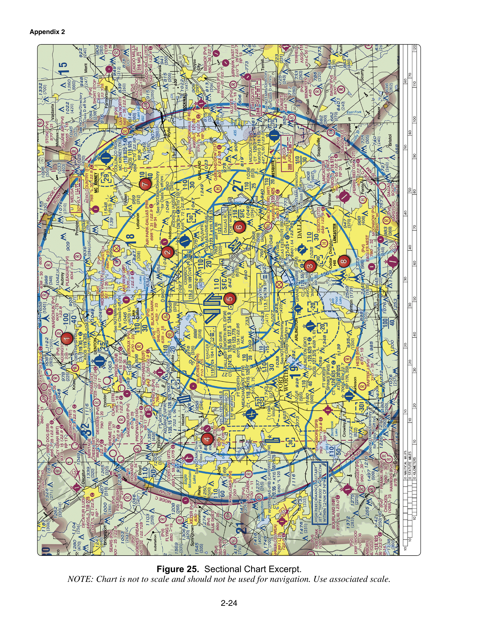
Class B airspace is charted with a solid blue line. Sector labels are hundreds of feet MSL with the last two zeros omitted, so 110 over SFC means from the surface to 11,000 feet MSL. Prior ATC authorization is required anywhere inside Class B, including a flight below 400 feet AGL. LAANC is an authorization path. It is not a waiver of the §107.51 altitude, speed, visibility, or cloud limits.
How the chart prints the shelf
The FAA Chart Users' Guide shows Class B ceiling and floor altitudes in solid blue figures, MSL, with the last two zeros omitted. On FAA-CT-8080-2H Figure 25, the Dallas–Fort Worth Class B sector this course uses is labeled 110 over SFC. The verification of that figure is the printed 110 over SFC near the Class B core. The matching altitude block is the surface to 11,000 feet MSL.
Read the fraction as ceiling over floor, then restore the zeros, then keep the unit as MSL. 110 becomes 11,000 feet. SFC means the floor is the surface. The block is not "from the surface to 1,100 feet AGL," which keeps the digits and changes both the unit and the number of zeros. It is also not "from 11,000 feet MSL upward with no printed ceiling," which swaps the top and the bottom and erases SFC.
A plus sign in front of a floor, where the chart prints one, means the floor is upward from above that altitude, so operations at and below the printed floor are outside that Class B shelf. The 110/SFC sector is the opposite case: the floor is the surface, and the airspace includes the altitudes where a drone flies.
Authorization first, including under 400 feet
Section 107.41 says no person may operate a small unmanned aircraft in Class B, Class C, or Class D airspace, or within the lateral boundaries of the surface area of Class E airspace designated for an airport, unless that person has prior authorization from ATC. The Class B sentence does not contain an exception for flights below 400 feet. If the solid blue line is around you and the sector floor is the surface, you are in Class B at rooftop height.
The usual ways to get the authorization are LAANC, where the UAS Facility Map publishes a grid, or FAADroneZone where LAANC is not available. A LAANC approval lets you operate up to that grid's ceiling, in that grid. It does not waive §107.51. If the grid says 100 feet, 400 feet is not authorized. If the grid says 400 feet, you still owe 87 knots, 3 statute miles of visibility from the control station, and the cloud distances. The LAANC page is the authorization path. The airspace classes page is the map of which classes use it.
Two contrasts the same bank asks next to Class B
Class A is largely irrelevant to Part 107 because it begins at 18,000 feet MSL, well above the drone altitude limit. The Chart Users' Guide describes Class A in the United States as extending from 18,000 feet up to FL600, and sectional charts do not depict it. The wrong reasons are "it requires no authorization" and "it only exists over oceans." It requires an ATC clearance for the manned aircraft that use it. It exists over the land. You will not plan a normal small UAS flight there, because §107.51 caps you at 400 feet AGL unless you are within 400 feet of a structure and no higher than 400 feet above that structure's top. Class A is a distractor that uses a real altitude. It is not the Class B shelf.
Class C is the other contrast, and it is a different chart symbol, covered on the Class C page. The question that asks for the first step into Class C keys the same legal act §107.41 requires in Class B: obtain ATC authorization, via LAANC or DroneZone, before operating. Simply flying because "drones are exempt" is wrong. Notifying the airport after landing is wrong. The authorization has to exist before the flight. That first step is identical in spirit for Class B. The chart work is what changes: solid blue and a label like 110/SFC, rather than solid magenta.
A roof inside the 110/SFC sector
Figure 25 shows the DFW Class B core labeled 110 over SFC. A roof inspection inside that line, at 200 feet AGL, is inside the sector. The surface is the floor and 11,000 feet MSL is the ceiling, so 200 feet AGL did not slip under the shelf. You obtain prior ATC authorization before launch. If LAANC offers a grid ceiling of 100 feet, you operate at or below 100 feet or you do not fly. You do not treat the Part 107 400-foot rule as a substitute for the authorization, and you do not treat the authorization as permission to ignore visibility and clouds.
The same morning someone asks whether the flight could just go up into Class A to "get above the Bravo." Class A starts at 18,000 feet MSL. That is not a Part 107 option. The legal path is authorization inside the Class B sector, at an altitude both the authorization and §107.51 allow.
The trap
The label trap drops two zeros in the wrong direction or switches MSL to AGL. 110 over SFC is the surface to 11,000 feet MSL. It is a closed block with a ceiling, not an open-ended floor at 11,000.
The authorization trap treats "below 400 feet" as outside §107.41. Section 107.41 is a regulation, and it applies in Class B at drone altitudes when the sector includes those altitudes. LAANC approves an altitude. It does not waive §107.51.
The contrast traps are the other two items on this page. Class A starts at 18,000 feet MSL, which is why it is usually irrelevant. The first step for Class C is prior authorization through LAANC or DroneZone, not a launch followed by a phone call.
Work Figure 25 on the free practice test. The chart lessons in the course put the solid blue line next to the MSL label so 110/SFC is read before anyone launches.