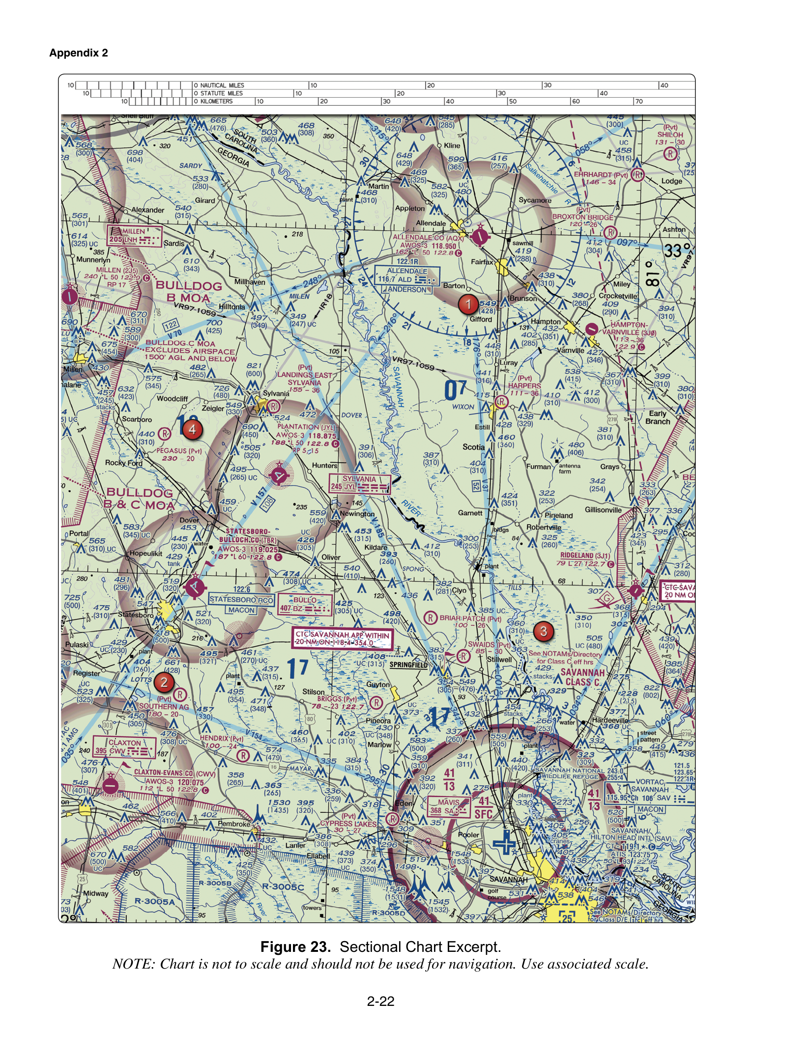
Class C airspace is charted with a solid magenta line. Sector altitudes are feet MSL with the last two zeros omitted. On FAA-CT-8080-2H Figure 23, Savannah's inner sector is labeled 41 over SFC, which is the surface to 4,100 feet MSL, and the outer shelf is labeled 41 over 13, which runs from 1,300 feet MSL up to a ceiling of 4,100 feet MSL. Prior ATC authorization is required before a Part 107 flight in that airspace.
Solid magenta, and the authorization that goes with it
A solid magenta boundary around an airport depicts Class C. Section 107.41 requires prior ATC authorization to operate in Class B, Class C, or Class D, and in Class E surface areas designated for an airport. The question about the solid magenta line keys Class C, and it keys that authorization for the controlled surface area. Class B is the solid blue line, so "no authorization below 400 feet" is the wrong class and the wrong rule. Class D is the dashed blue line, and a two-way radio is not the Part 107 substitute for prior authorization.
The Chart Users' Guide prints Class C ceilings and floors in solid magenta figures with the last two zeros eliminated. Restore the zeros and keep MSL. A ceiling printed as T, where you see one, means up to but not including the floor of overlying Class B. Savannah's labels in this figure are numbers, not T.
The line style is easy to confuse with other magenta. A dashed magenta line is Class E at the surface. A faded magenta vignette is a Class E floor at 700 feet AGL. A wide solid magenta ring about 30 nautical miles from some Class B airports is the Mode C veil, which is not Class C. The solid magenta Class C boundary is the airport airspace itself. Color and line style are compared on the magenta and blue page. Class B's solid blue line is the neighboring case on the Class B page.
41 over SFC is the inner, surface sector
Figure 23 prints 41 over SFC on the inner Class C sector at Savannah/Hilton Head International. The verification note on that item is the inner label 41 over SFC and the outer label 41 over 13. Class C sector figures are MSL with two zeros omitted. 41 is 4,100 feet MSL. SFC is the surface. The sector runs from the surface to 4,100 feet MSL.
It does not run from the surface to 410 feet AGL. That reading keeps "41" as a drone-sized number and changes the datum. It also does not run from 1,300 feet MSL up to 4,100 feet MSL. That is a different label, the shelf, borrowed and pasted onto the surface sector. The inner sector includes the altitudes a small unmanned aircraft actually uses. A roof at 150 feet AGL inside the inner line is in Class C.
41 over 13: the ceiling is 4,100 feet MSL
The outer shelf on the same figure is 41 over 13. The upper number is the ceiling and the lower number is the floor. 41 is 4,100 feet MSL. 13 is 1,300 feet MSL. The question asks for the ceiling, and the keyed answer is 4,100 feet MSL. 1,300 feet AGL is the floor with the wrong unit. 410 feet AGL drops a zero and changes the unit.
Under the shelf, below 1,300 feet MSL, you are outside that Class C shelf. Whether the surface there is Class G or something else depends on what else the chart designates. Inside the shelf, from 1,300 feet MSL up to 4,100 feet MSL, you are in Class C. The inner sector is the one that reaches the surface. Do not use the shelf floor as if it were the surface sector's floor.
Authorization follows the airspace you are actually in. Inside the lateral and vertical limits, §107.41 applies. LAANC or DroneZone is how you get the prior authorization. A grid ceiling below the Part 107 400-foot rule is the altitude you may use. The authorization does not waive §107.51.
Reading Savannah before a launch
You have Figure 23 and a job near Savannah. You find the solid magenta boundary and the inner label 41 over SFC. You are inside that inner sector at ground level. The airspace runs from the surface to 4,100 feet MSL, so the planned 200-foot AGL pass is inside Class C. You get ATC authorization before you fly. You do not launch and call someone afterward, and you do not decide that a solid magenta line is Class B or Class D.
If the site were out under the outer ring instead, you would read 41 over 13 as a ceiling of 4,100 feet MSL and a floor of 1,300 feet MSL. A Part 107 flight at a few hundred feet AGL may be under that shelf, in whatever airspace the chart shows below 1,300 feet MSL. You still confirm the floor in feet MSL against the terrain, because a high field elevation can put 400 feet AGL up into the shelf. The label itself stays MSL.
The trap
The color trap calls solid magenta Class B or Class D, and then relaxes the authorization. Solid magenta is Class C, and the surface area needs prior ATC authorization.
The surface-sector trap turns 41/SFC into 410 feet AGL or into the shelf's 1,300-foot floor. It is the surface to 4,100 feet MSL.
The shelf trap asks for the ceiling and offers the floor, or offers 410 feet. On 41 over 13 the ceiling is 4,100 feet MSL. The inner sector on the same figure is the other label, 41 over SFC.
Practice Figure 23 on the free practice test. The sectional lessons in the course make you restore the two zeros before you decide the flight is under the shelf.