A military training route is a path where military aircraft train, often at low altitude and high speed: VR means a VFR military training route, and IR means an IFR military training route. Part 107 does not ban a remote pilot from crossing an MTR. The hazard is fast, low military traffic, not a hidden airspace class.
What the letters and the digits mean
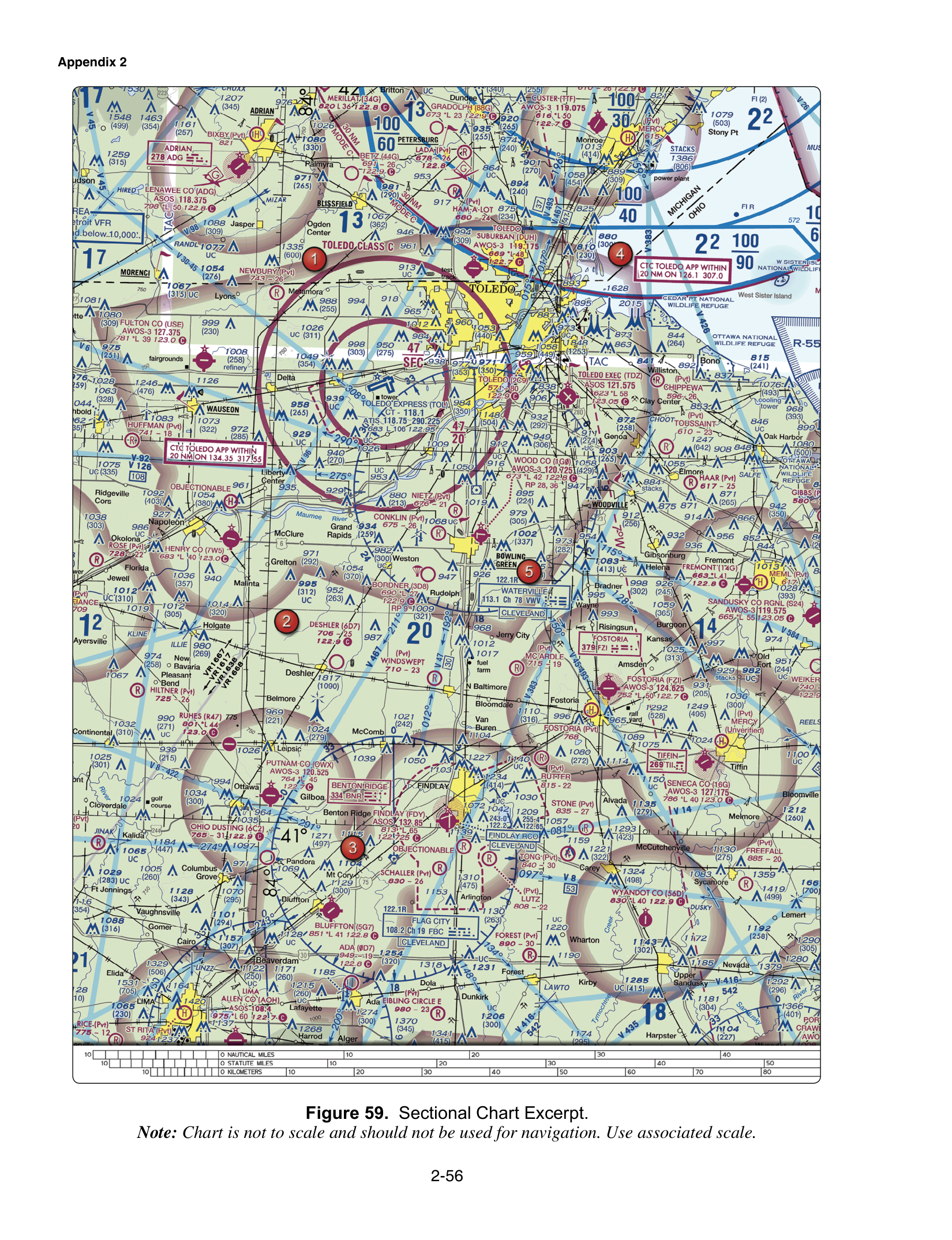
FAA-CT-8080-2H Figure 59, the Toledo excerpt in this course, prints a gray line labeled VR1667, VR1617, VR1638, and VR1668. Those identifiers mark VFR military training routes. A Victor airway is a blue line labeled with a V, not VR. The same labels are not visual reporting points on a Class B arrival. If the stem says IR, that designator is an IFR military training route. The chart note distinguishes the two families: four-digit routes are generally developed for VFR, and routes with one or more segments above 1,500 feet AGL are developed to be flown, as far as practical, under IFR.
AIM 3-5-2 is the digit rule. A route with no segment above 1,500 feet AGL is identified by four numbers, such as VR1667. A route with at least one segment above 1,500 feet AGL is identified by three digits. The Chart Users' Guide states the same split and notes that three-or-fewer-digit routes drop any leading zeros, so IR21 is the printed form of a low-number IFR route. Four digits does not mean every segment is above 1,500 feet AGL. It means the opposite: no segment of that route is above 1,500 feet AGL.
The sectional shows the route centerline, with small arrowheads for the direction of flight. When several routes share the same airspace, the chart may print the designators together rather than repeating VR or IR on every label. The sectional prints the centerline. It does not print one fixed width, and Part 107 does not state a corridor distance to memorize. The Chart Users' Guide points the detailed width to the Department of Defense flight information publication.
How a remote pilot uses the route
An MTR is other charted airspace information. It is not an airspace class, it is not Class B, and it is not the same thing as a restricted area. It does not automatically authorize a drone flight, and it does not prohibit one by its ink alone. Military aircraft may operate at high speed and at low altitude, including on the four-digit routes that have no segment above 1,500 feet AGL. Those aircraft can be in the same altitudes as a small unmanned aircraft. Staying under the 400-foot Part 107 limit does not place you clear of a four-digit VR route.
The practical step is the one the ACS expects. Identify the route on the chart, check current information for activity, and plan the flight so you do not conflict with the training. A NOTAM briefing is part of that check. A Military Operations Area is a different depiction, with its own cautions, covered on the MOA and restricted area page. Do not treat the gray VR line as an R-area you must get agency permission to cross, and do not treat a real restricted area as if it were only an MTR.
The Toledo line, read as a test figure
On Figure 59 the gray line near Toledo carries four VR identifiers, each with four digits. The letters answer the "what is this line" question: VFR military training routes. The digit count answers the altitude question: no segment of those routes is above 1,500 feet AGL. A choice that calls the line a Victor airway, a VOR radial, or a Class B reporting point is reading a V that is not printed. A choice that says every segment is above 1,500 feet AGL, so a small unmanned aircraft below 400 feet is clear, has the four-digit rule backward. Four-digit routes are the ones that can be flown low and fast, in the band where a Part 107 flight actually operates.
The trap
The exam stacks three confusions. VR is not a Victor airway. Four digits is not "high route, you are safe underneath." And the line is not a restricted area, a Class B shelf, or a permission slip for the drone. The accurate statement for a small unmanned aircraft pilot is that military training activity may occur, often low and fast, so you check current information and avoid the conflict. Class G under the route, where it exists, still has the 400-foot rule. The route's presence does not waive it.
Work Figure 59 on the free practice test. The airspace lessons that sit next to this chart are in the course.